You are in: South America -> Bolivia -> Fuerte de Samaipata, and traditional search or Image Gallery will yield results of this site only
Fuerte de Samaipata
| Site number: | 883 |
|
| Type of site: | Cultural | |
| Date: | 14th-16th c. | |
| Date of Inscription: | 1998 | |
| Location: | South America, Bolivia, Province of Florida, Department of Santa Cruz | |
Up to 75 images are shown here. Click on each for more details or on Image Gallery for more images.
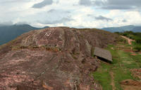
| Description: | The archaeological site of Samaipata is comprised of a hill with many carvings (believed to have acted as the old town’s ceremonial centre between 14th–16th centuries), and the area to the south of the hill (which once formed the administrative and residential quarter). The town is dominated by a huge sculptured rock, unparalleled in the Americas, which stands as a unique testimony to pre-Hispanic traditions and beliefs. --WHMNet paraphrase from the description at WHC Site, where additional information is available. | |
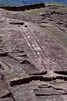
| Fuerte de Samaipata (English: Fort Samaipata), also known simply as 'El Fuerte', is an archaeological site and UNESCO World Heritage Site located in Santa Cruz Department, Bolivia. It is situated in the eastern foothills of the Bolivian Andes, and is a popular tourist destination for Bolivians and foreigners alike. It is served by the nearby town of Samaipata. It is not actually a military fortification but it is generally considered a pre-Colombian religious site, possibly built by pre-Incas. More recently, it has been pronounced to be a flying saucer launching and landing site by Erich Von Daniken, well known author of "Chariots of the Gods?" This is lent credence in certain circles due to the parallel sloping grooves cut into the rock at the highest point of the site. Archaeologists, however, contend that the unusual carvings may be from a pre-Inca civilization on this Amazonian slope who were commemorating the flyover of Halley's Comet in March 1066 CE. The most important feature of El Fuerte seems to be El Cascabel. El Cascabel can be translated as 'the back of the (rattle)snake'. Two parallel lines point to certain points in the eastern sky at a position of azimuth 71° and an altitude of about 6.75° . One can have looked along the parallel lines, standing on the place of observation in front of the Inca-wall at the foot of El Fuerte and watched the parallel rising of two planets at sunrise on august 20 1066 AD above both lines against the background of constellation Leo: Venus and Jupiter. --Wikipedia. Text is available under the Creative Commons Attribution-ShareAlike License. | ||
| Source: | http://whc.unesco.org/en/list/883 | |
| Reference: | 1. UNESCO World Heritage Center, Site Page. | |


