You are in: Africa -> Niger -> Air and Ténéré Na... , and traditional search or Image Gallery will yield results of this site only
Air and Ténéré Natural Reserves
| Site number: | 573 |
|
| Type of site: | Natural Heritage in danger | |
| Date of Inscription: | 1991 | |
| Location: | Africa, Niger, Départment d’Agades, arrondissement d’Arlit | |
Up to 75 images are shown here. Click on each for more details or on Image Gallery for more images.
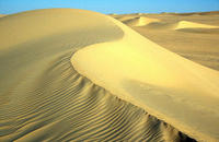
| Description: | Air and Ténéré Natural Reserves is Africa’s largest protected area, covering some 7.7 million ha, though the area regarded as a protected sanctuary forms only one-sixth of the total area. Situated in the Saharan desert of Ténéré within this smaller area is the volcanic rock mass of the Aïr, a tiny Sahelian pocket, remote in its climate and flora and fauna. The reserves possess an exceptional range of landscapes, plant species and wild animals. --WHMNet paraphrase from the description at WHC Site, where additional information is available. | |
| The Ténéré is a desert region in the south central Sahara. It comprises a vast plain of sand stretching from northeastern Niger into western Chad, occupying an area of over 154,440 square miles (400,000 km²). Its boundaries are conventionally said to be the Aïr Mountains in the west, the Ahaggar Mountains in the north, the Djado Plateau in the northeast, the Tibesti Mountains in the east and the basin of Lake Chad in the south. The central part of the desert, the Erg du Ténéré, is located at approximately 17°35′N, 10°55′E. The Ténéré was featured in a Discovery Travel & Living documentary ("Journeys to the End of the Earth: The Land of Fear"). The name Ténéré comes from the Tuareg language meaning literally "desert", in much the same way that the Arabic word for "desert", sahara, came to be applied to the region as a whole. --Wikipedia. Text is available under the Creative Commons Attribution-ShareAlike License. | ||
| Source: | http://whc.unesco.org/en/list/573 | |
| Reference: | 1. UNESCO World Heritage Center, Site Page. | |


