You are in: Asia -> Korea, Republic of -> Jeju Volcanic Island... , and traditional search or Image Gallery will yield results of this site only
Jeju Volcanic Island and Lava Tubes
| Site number: | 1264 |
|
| Type of site: | Natural | |
| Date: | - | |
| Date of Inscription: | 2004 | |
| Location: | Asia, Republic of Korea, 130 kilometers off the southern coast of Korea | |
Up to 75 images are shown here. Click on each for more details or on Image Gallery for more images.
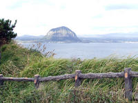
| Description: | Taking up 10.3% of the surface area of Jeju Island in the southernmost territory of the Republic of Korea is the Jeju Volcanic Island and Lava Tubes that encompass three sites that cover 18,846 h. The site is composed of: Geomunoreum, considered the finest lave tube system of caves in the world, holds multi-coloured carbonate roofs and floors, and dark-coloured lava walls; the fortress-like Seongsan Ilchulbong tuff cone, that climbs out of the ocean and creates a dramatic landscape; and Mount Hallasan, Korea’s highest, boasting waterfalls, variously shaped rock formations, and a lake-filled crater. Exceptionally beautiful aesthetically, the property also bears witness to our planet’s history, it many features and processes. --WHMNet paraphrase from the description at WHC Site, where additional information is available. | |
| The Jeju Volcanic Island and Lava Tubes is a World Heritage Site in South Korea. Jejudo is a volcanic island, 130 kilometers from the southern coast of Korea. The largest island and smallest province in Korea, the island has a surface area of 1,846 square kilometers. A central feature of Jeju is Hallasan, the tallest mountain in South Korea and a dormant volcano, which rises 1,950 meters above sea level. 360 satellite volcanoes are part of the main volcano. Volcanic activity on Jeju began approximately in the Cretaceous and lasted until the early Tertiary period. The last recorded volcanic activity was recorded approximately 800 years ago. The island is covered in volcanic rock and volcanic soil produced by Hallasan. Baengnokdam, the crater and lake in it are located at the peak of Hallasan, was formed over 25,000 years ago while. Jeju is scientifically valuable for its extensive system of lava tubes (also known as lateral volcanoes or in Korean as Oreum). These natural conduits through which magma once flowed are now empty caves that are some of the largest in the world. The caves provide opportunities for scientific research and are also popular tourist destinations. Off the shores of the city of Seogwipo are a vast belt of pillar-shaped rocks that are examples of the natural beauty of Jeju. Shellfish and animal fossils discovered in this area are also very valuable as scientific resources. Beomseom Island and Moonseom Island, also off the city seacoast, are also well preserved and scenic areas. The variety of animal and plant species on Jeju is also an important reason for its value as a natural reserve. Half of all Korean vascular plants grow naturally on the island while another 200 species of plants indigenous to Korea have been transported here. However, half of these species face extinction. The polar plants which came from the south during a glacial period and inhabit the peak of Jeju is one example. Other plants in the subtropical forest and lower regions of the island are also endangered. --Wikipedia. Text is available under the Creative Commons Attribution-ShareAlike License. | ||
| Source: | http://whc.unesco.org/en/list/1264 | |
| Reference: | 1. UNESCO World Heritage Center, Site Page. | |


