You are in: Europe -> Switzerland -> Swiss Tectonic Arena... , and traditional search or Image Gallery will yield results of this site only
Swiss Tectonic Arena Sardona
| Site number: | 1179 |
|
| Type of site: | Natural | |
| Date: | - | |
| Date of Inscription: | 2008 | |
| Location: | Europe, Switzerland, Alps | |
Up to 75 images are shown here. Click on each for more details or on Image Gallery for more images.
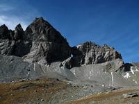
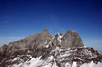
| Description: | The 32,850 ha mountainous area of the Swiss Tectonic Arena Sardona in the country’s north-eastern part possesses seven peaks that climb more than 3,000 m above sea level. Through continental collision an outstanding illustration of mountain building can be observed in the area, which also presents exceptional geological divisions through tectonic thrust, i.e. the progression through which older, deeper rocks are passed onto younger, shallower rocks. The site is differentiated by its obvious three-dimensional exposure of the structures and processes that distinguish this ccurrence; since the 18th century it has been a significant site for the geological sciences. The glaciated mountains, Glarus Alps, ascend dramatically above slender river valleys and have the Central Alpine region’s largest post-glacial landslide. --WHMNet paraphrase from the description at WHC Site, where additional information is available. | |
| The Glarus thrust (German: Glarner Überschiebung) is a major thrust fault in the Alps of eastern Switzerland. Along the thrust the Helvetic nappes were thrusted more than 100 km to the north over the external Aarmassif and Infrahelvetic complex. The thrust forms the contact between older (Helvetic) Permo-Triassic rock layers of the Verrucano group and younger (external) Jurassic and Cretaceous limestones and Paleogene flysch and molasse. The Glarus thrust crops out over a relatively large area in the cantons Glarus, St. Gallen and Graubünden, due to its horizontal orientation and the high local relief. Famous outcrops include those at Lochsite near Glarus (the town) and in a mountain cliff called Tschingelhörner between Elm and Flims (in the same cliff is a natural hole called the Martinsloch). --Wikipedia. Text is available under the Creative Commons Attribution-ShareAlike License. | ||
| Source: | http://whc.unesco.org/en/list/1179 | |
| Reference: | 1. UNESCO World Heritage Center, Site Page. | |


