You are in: Middle East -> Syria -> Ancient Villages of ... , and traditional search or Image Gallery will yield results of this site only
Ancient Villages of Northern Syria
| Site number: | 1348 |
|
| Type of site: | Heritage in danger | |
| Date: | lst-7th century | |
| Date of Inscription: | 2011 | |
| Location: | Middle East, Syraina Arab Republic, north-western Syria | |
Up to 75 images are shown here. Click on each for more details or on Image Gallery for more images.
Six official UN languages:
Arabic,
Chinese,
English,
French,
Russian,
Spanish
Other languages: Catalian, Dutch, German, Hungarian, Italian, Japanese, Portuguese, Slovenian, Swedish
Other languages: Catalian, Dutch, German, Hungarian, Italian, Japanese, Portuguese, Slovenian, Swedish
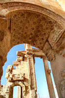
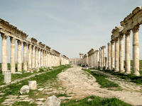
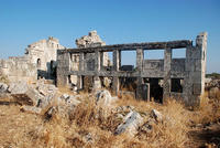
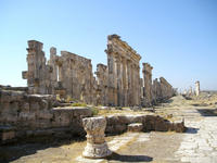
| Description: | Some 40 villages grouped in eight parks situated in north-western Syria provide remarkable testimony to rural life in late Antiquity and during the Byzantine period. Abandoned in the 8th to 10th centuries, the villages, which date from the 1st to 7th centuries, feature a remarkably well preserved landscape and the architectural remains of dwellings, pagan temples, churches, cisterns, bathhouses etc. The relict cultural landscape of the villages also constitutes an important illustration of the transition from the ancient pagan world of the Roman Empire to Byzantine Christianity. Vestiges illustrating hydraulic techniques, protective walls and Roman agricultural plot plans furthermore offer testimony to the inhabitants' mastery of agricultural production. --WHMNet's description is from WHC Site, where additional information is available. | |
| The Church of Saint Simeon Stylites (Arabic: كنيسة مار سمعان العمودي Kanīsat Mār Simʿān al-ʿAmūdī) is a historical building located about 30 km northwest of Aleppo, Syria. The oldest surviving Byzantine church dating back to the 5th century, it is based in the dead city of Telanissos, which is adjacent to the ancient city of Antioch. Built on the site of the pillar of St. Simeon Stylites, a famed hermit monk, the church is popularly known as either Qalaat Semaan (Arabic: قلعة سمعان Qalʿat Simʿān), the 'Fortress of Simeon', or Deir Semaan (Arabic: دير سمعان Dayr Simʿān), the 'Monastery of Simeon' . ---------------- Apamea (Greek: Απάμεια, Apameia; Arabic: آفاميا, Afamia) was a treasure city and stud-depot of the Seleucid kings, was capital of Apamene, on the right bank of the Orontes River. (Steph. B. s. v.; Strabo xvi. p. 752; Ptolemy v. 15. § 19; Festus Avienus, v. 1083; Anton. Itin.; Hierocles). Its site is found about 55 km (34 mi) to the northwest of Hama, Syria, overlooking the Ghab valley. Previously known as Pharmake, it was fortified and enlarged by Seleucus I Nicator in 300 BC, who so named it after his Bactrian wife, Apama – not his mother, as Stephanus asserts (compare Strabo, p. 578). In pursuance of his policy of Hellenizing Syria, it bore the Macedonian name of Pella. The fortress was placed upon a hill; the windings of the Orontes, with the lake and marshes, gave it a peninsular form, whence its other name of Cherronêsos. Seleucus had his commissariat there, 500 elephants, with 30,000 mares, and 300 stallions. The pretender, Diodotus Tryphon, made Apamea the basis of his operations. (Strab. l. c.) Located at a strategic crossroads for Eastern commerce, the city flourished to the extent that its population eventually numbered half a million. It was one of the four cities of the Syrian tetrapolis. --Wikipedia. Text is available under the Creative Commons Attribution-ShareAlike License. | ||
| Source: | http://whc.unesco.org/en/list/1348 | |
| Reference: | 1. UNESCO World Heritage Center (http://whc.unesco.org/en/list/1348). 2. Wikipedia. | |


